📍 El Laberinto (Rock Labyrinth)
Red rock pillars sculpted by wind and water — bizarre in shape like nature’s sculpture park, great for hiking and photos.
Argentina · Mendoza Province · San Rafael
Atuel Canyon · Hydraulic Canyon · Andean Precordillera
📍 RP173, Cañón del Atuel, San Rafael, Mendoza, Argentina
📞 Visitor info: San Rafael Tourism
🏛️ Natural Wonder · Canyon & Reservoirs
Welcome to Cañón del Atuel, widely recognized as the central Atuel Canyon. Located in the heart of San Rafael, Mendoza, Argentina, this destination serves as a primary hub for travelers visiting the region.
Cañón del Atuel unfolds along the RP173 provincial road, about 40 km south of San Rafael. The map below marks the exact coordinates of the attraction, so you can plan a self-drive or private-transfer route.
RP173, Cañón del Atuel San Rafael, Mendoza Province Argentina
View on Google MapsWhen visiting Cañón del Atuel, visitors can easily explore surrounding historical landmarks and points of interest, including El Laberinto (Rock Labyrinth) and Valle Grande Reservoir.
Red rock pillars sculpted by wind and water — bizarre in shape like nature’s sculpture park, great for hiking and photos.
One of the Atuel’s cascading reservoirs; turquoise water against ochre cliffs, with boat rental, fishing and leisure.
A broad downstream reservoir with calm water — popular for sailing, water-skiing and lakeside camping.
From the Huarpe vision of “water like an arrow” to the completion of five cascading reservoirs in the 20th century, the history of Cañón del Atuel is at once geological and the story of Mendoza’s hydraulic works and oasis civilisation.
Canyon Overview00
Mendoza Province is famous for its Precordillera canyons and reservoirs. When planning a trip, the three easiest to confuse are Cañón del Atuel, Potrerillos (Cañón del Río Mendoza) near Mendoza city, and the Uspallata valley on the way to Aconcagua. They differ in landscape and experience.
| Destination | Region | Landscape Type | Core Experience | Best For |
|---|---|---|---|---|
| Cañón del Atuel | San Rafael | Deep gorge + five linked reservoirs | RP173 scenic drive, rafting, zip-line | Road-trippers, adventurers and photographers |
| Potrerillos Canyon | Near Mendoza city | Single reservoir (Embalse Potrerillos) + gorge | Half-day rafting, climbing, lakeside leisure | Half-day visitors from Mendoza city |
| Uspallata Valley | Andean pass, west Mendoza | High-altitude valley with Inca sites | Scenic drive, stopover to Aconcagua | Cross-border drivers and high-mountain travellers |
Region: San Rafael
Landscape Type: Deep gorge + five linked reservoirs
Core Experience: RP173 scenic drive, rafting, zip-line
Best For: Road-trippers, adventurers and photographers
Region: Near Mendoza city
Landscape Type: Single reservoir (Embalse Potrerillos) + gorge
Core Experience: Half-day rafting, climbing, lakeside leisure
Best For: Half-day visitors from Mendoza city
Region: Andean pass, west Mendoza
Landscape Type: High-altitude valley with Inca sites
Core Experience: Scenic drive, stopover to Aconcagua
Best For: Cross-border drivers and high-mountain travellers
01
Cañón del Atuel is one of Mendoza Province’s most stunning natural and engineered landscapes, set in the Precordillera of the Andes south of San Rafael. The Atuel River plunges down from the snowy Andes and has carved a deep canyon through arid, red rock — then been chained by a series of reservoirs that turn turquoise lakes and ochre cliffs into a single, unforgettable panorama. How the Canyon Was Born The Atuel River rises in the Andes of south-west Mendoza and runs about 185 km. For millions of years it has incised along geological faults, cutting ancient sedimentary and volcanic rock into a profound gorge. At its narrowest, only a sliver of sky shows; the walls display layered hues of red, orange and grey. Taming the Water: the Legend of the Atuel Reservoirs From the mid-20th century, Mendoza built a cascade of reservoirs on the Atuel — Valle Grande, Tierras Blancas, Aisol and El Nihuil — to generate hydropower and irrigate the land. (Agua del Toro and Los Reyunos, often mentioned nearby, are part of the separate Río Diamante basin.) The river was cut section by section, and in the middle of the desert canyon appeared its linked turquoise lakes, making this one of Argentina’s most remarkable hydraulic landscapes and the source of power and life for the San Rafael oasis. Mendoza's "Water Bank" Today the Atuel basin supplies a significant share of Mendoza’s electricity and irrigation water. The reservoir chain is both a lifeline for energy and agriculture and the stage for rafting, zip-lines and lakeside leisure — a rare symbiosis of natural force and human engineering.
The name Atuel comes from the Huarpe (Allentiac) language of the region’s original inhabitants, evoking water that shoots down like an arrow. Between the canyon and its reservoirs, stories of this land still live on.
The Huarpe were among the oldest peoples of Mendoza, living along rivers and lakes and naming nature with simple, poetic words. In Huarpe, Atuel is read as water that bursts forth like an arrow — a perfect description of the Atuel River’s rush through the gorge. The San Rafael oasis of today flourishes precisely because of this river.
Although Huarpe culture was severely disrupted during the colonial period, their place-names and reverence for water survive in Mendoza’s geographic memory. As you walk beside a reservoir, remember: this turquoise water was once a sacred, rushing stream in Indigenous eyes.
Unlike many natural wonders, the modern legend of Cañón del Atuel is human. From the 1940s, Mendoza’s engineers and workers dammed the river, turning the wild Atuel into a string of gentle lakes. Older residents of San Rafael still recall that when the reservoirs were completed, the barren canyon first mirrored a turquoise reflection, and the oasis lit up with hydroelectric power.
This history of taming the water makes Cañón del Atuel a vivid lesson in how humans reshape — and coexist with — nature: a reminder that here, half the beauty is from the earth, and half from human hands.
In the oral tradition of Mendoza’s countryside, the canyon and reservoirs are not entirely silent. One story says that when the wind brushes the reservoir surface and a low hum echoes through the rocks, it is the spirit of the water reminding people to respect this river of life. Elders also warn against entering the gorge rapids after heavy rain, for the swollen river holds formidable power.
These simple tales, continuous with the Huarpe reverence for water, form the soft yet clear human undertone of Cañón del Atuel.
If Cañón del Atuel is seen only as a driving destination, its longer formation story disappears. This timeline reconnects geology, water and human activity on one line.
Ancient sedimentary and volcanic rock accumulated in the Precordillera, forming the bedrock later cut by the river.
The Andes raised the regional relief and drainage gradient, and the Atuel River incised along the faults.
In its rhythm of dry-season trickles and rainy-season floods, the Atuel cut the rock into today’s deep ochre gorge.
For power and irrigation, five reservoirs were built — Agua del Toro, Los Reyunos, Valle Grande, Tierras Blancas and El Nihuil — shaping the linked turquoise landscape.
The canyon is a hub for rafting, zip-lines and scenic drives, while protected as a sensitive ecosystem sustaining Mendoza’s water and power.
02
Cañón del Atuel is a double masterpiece of natural force and engineering wisdom. Its unique landforms are valuable for both appreciation and research, and tell the story of how humans harness Andean water.
The Atuel River incises along faults in the Andean Precordillera, forming a classic deep gorge (garganta). Dozens of kilometres long with towering walls, it narrows in places to barely allow two vehicles. The riverbed surges in the rainy season and trickles in the dry — relentless incision over millions of years shaped today’s deep cleft. The canyon walls are mostly ancient sedimentary and volcanic rock, recording the long history of Andean orogeny. Erosion is especially strong where rock is softer, producing step-like cliffs and potholes.
The cliffs are an open geological textbook: red, orange and grey bands from minerals deposited in different eras — iron oxide gives the red, calcium carbonate the pale stripes. Under the low-angle morning and evening sun, the colours are most intense, contrasting sharply with the turquoise lake — a favourite subject for photographers.
The Atuel has limited annual runoff with strong seasonal swings. To regulate flow, generate power and irrigate, Mendoza built a cascade of reservoirs on the Atuel, storing flood-season water for both flood control and energy. The reservoir chain tamed the wild river into something gentle and controllable, creating a unique hydraulic canyon: bare rock next to blue water, wilderness next to oasis.
03
Cañón del Atuel blends canyon sightseeing, water sports and Precordillera scenery. The experiences below are loved by adventurers, photographers and families alike.
The Atuel is one of Mendoza’s most famous rafting rivers. Trips from San Rafael run through rapids and calm stretches beneath towering canyon walls — a double feast of adrenaline and scenery. Kayakers can also enjoy the gentler reservoir sections amid lake and mountain views.
Canopy (zip-line) and high-rope courses near the canyon let visitors skim above the ochre cliffs and blue lakes from a bird’s-eye view. A popular choice for families and teams, with safety gear provided by professional operators.
Driving the RP173 is the classic way to experience the canyon. The road winds along the cliff edge with several miradores (viewpoints) to stop and gaze over reservoirs and the rock labyrinth — a paradise for photographers and sunset lovers.
Several hiking and mountain-bike trails of varying difficulty surround the canyon. Whether capturing the texture of red rock, waiting for a condor to glide, or watching morning mist lift off the reservoir, the canyon rewards slow travel.
Lago Atuel · El Nihuil · Volcán Overo
The canyon itself is only the stage. What actually shapes a visit is the chain of lakes, rock formations and volcanic terrain unfolding along RP173. The six places below are listed in driving order so you can prioritise your stops.
The lake created where the Atuel river is held back by the El Nihuil dam — and the name of the small settlement on its shore. Turquoise water, wide banks and the highest concentration of rafting, kayaking, speedboat rides and swimming in the canyon.
Water activities run from morning to late afternoon — confirm departures for the day before deciding your stop order.
Lago Atuel activities guide →The lowest and most accessible of the five cascading reservoirs, with calm open water used year-round for sailing and windsurfing. El Nihuil village on its shore has food, camping and supplies — a natural finish to the drive.
Save it for the second half of your day so you can refuel and rest here before heading back.
A small volcanic cone near El Nihuil and one of the few volcanic landforms in the area. From the top you look out over the reservoir and the surrounding lava plateau — a striking contrast with the sedimentary canyon walls, and a favourite stop for photographers.
The approach is mostly dirt side-road and conditions change with the season — use a high-clearance vehicle and confirm access with the local tourism office beforehand.
Red rock pillars carved by wind and water into an interlocking maze of passages — hence the name. You can park and walk among them to see the bedding planes and erosion up close.
The rock is loose and there is almost no shade — wear grippy shoes and avoid the midday sun.
The first reservoir you reach on entering the canyon from San Rafael. Turquoise water meets ochre cliffs head-on here — the most iconic single view of the whole drive, and the first stop on most itineraries.
Early-morning and late-afternoon side-light brings out the rock strata best — schedule this one for the best light you have.
One of the Atuel’s cascading reservoirs closest to San Rafael, with winding bays, bright water and water-sports facilities around it — a good half-day side trip.
It is reached from a different direction than the canyon road, so plan it as a separate half day rather than mixing it into an RP173 day.
Rafting · Kayak · Hiking · 4x4
Things to do here split into water and land: water activities cluster around Lago Atuel and the reservoirs, while land activities mean driving RP173, hiking the rock formations and visiting the volcanic cone. Most activities need booking ahead.
The signature activity of the canyon. Difficulty varies with how much water is released from the dams; operators assess conditions and provide helmets and life jackets, usually including transfers and a guide.
2–4 hrs · Booking required · Subject to water levels
Done on the calmer stretches such as Lago Atuel and El Nihuil — ideal if you want to set your own pace without missing the lake scenery.
1–2 hrs · Beginner friendly
The reservoir areas offer boat trips and fishing. Best on calm, low-wind days and a good option for families or anyone who would rather stay dry.
~1 hr · On site or booked
Mainly El Laberinto and the roadside viewpoints. Low intensity walking, focused on seeing the rock strata and the canyon cross-section up close.
1–3 hrs · No specialist gear
Off-road trips out to Volcán Overo and the surrounding dirt tracks, led by local operators — far more reliable than working out the access yourself.
Half day · Guide recommended
The canyon has an arid, very clear atmosphere. Side-light at dawn is best for the rock strata, and once night falls you are far from town light pollution — excellent for astrophotography.
Sunrise / sunset / night
There is no public transport that drops you at the viewpoints, so in practice there are three ways to do this. In peak season and on public holidays, confirm availability at least a day ahead.
Self-drive or rental (most freedom)
Set your own pace along RP173 — best if you want to control timing or shoot the sunrise. Fill the tank in San Rafael and download offline maps before you enter.
~40 km · Half day to full day
Local day tour / half-day tour
Run by San Rafael agencies and including vehicle, driver and stops at the main viewpoints; some itineraries can add rafting or a boat ride.
Half or full day · Book ahead
Private transfer & driver
Best for families, small groups or anyone carrying camera gear. You choose the stops and the time spent at each — the most flexible option.
Priced per vehicle · Full day available
Atuel Canyon tours from San Rafael · full RP173 road trip guide
04
Reading Notes
This page focuses on Cañón del Atuel south of San Rafael — a landscape written jointly by natural incision and 20th-century hydraulic engineering. We summarise geological context, practical transport and safety notes to help you plan with clear expectations.
Cañón del Atuel is both a natural heritage and a sensitive ecosystem that sustains Mendoza’s water and power. As an independent non-profit educational guide, we advocate visiting this land in the most responsible way.
05
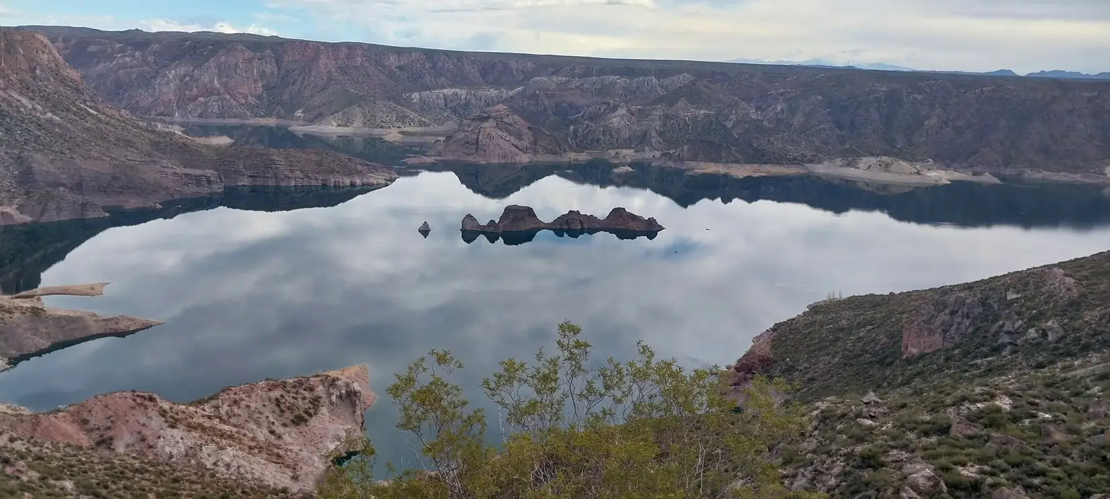
What moves visitors most about Cañón del Atuel is the contrast between nature’s hardness and engineerings softness. On one side, ochre bare rock cut over millions of years; on the other, a river-dammed, jade-like turquoise reservoir. Two images that capture the canyon’s dual character.
Bare Rock Canyon
Turquoise Reservoir
06
Cañón del Atuel can be visited year-round. A half-day along RP173 or a full day combining reservoirs and San Rafael is recommended. The following helps you plan with ease.
07
Cañón del Atuel is a linear scenic area along the RP173 provincial road: you start in San Rafael city, pass a series of viewpoints and reservoir service areas, and end near El Nihuil. Facilities are scattered in points along the road, and how well you prepare in advance largely determines the experience. The list below covers each type of facility.
This site is an independent non-profit educational project. The information below is a neutral description by facility type only — we do not recommend or endorse any specific business, brand or price. Actual opening hours and availability should be confirmed on site and through official sources.
Main viewpoints & reservoir service areas
Public restrooms are available at the main viewpoints, reservoir leisure areas and dining points, usually maintained by the operator of each service area. The deeper road sections and cliff-edge viewpoints generally have no fixed restrooms — go before leaving San Rafael city or El Nihuil.
Roadside bays at viewpoints
Most viewpoints have free roadside parking bays with limited capacity. On peak days and long weekends bays fill up in the morning. Do not park on emergency lanes, curves or cliff-edge sections; buses and motorhomes should use the larger reservoir areas.
Reservoir service areas & San Rafael city
There are dining points at reservoir leisure areas and some viewpoints, typically offering standard categories such as grilled food, light meals, coffee and cold drinks; menus and opening hours vary strongly by season. San Rafael city has the widest choice — eat there or bring your own snacks and water.
San Rafael city & around the reservoirs
There is no lodging inside the canyon. Accommodation is concentrated in San Rafael city (hotels, hostels and guesthouses), with camping and cabin-style options near the reservoirs and El Nihuil. Book ahead in high season.
San Rafael city, El Nihuil
Supermarkets, convenience stores and pharmacies are concentrated in San Rafael city; El Nihuil and some reservoir areas have small shops for water, ice and snacks. There are no large stores along the canyon — do your shopping before you enter.
Densest in San Rafael city
Fuel stations are densest in San Rafael city, with a few near El Nihuil and some reservoir areas; there are almost none along the canyon road. Public EV charging is concentrated in San Rafael city — there are no public chargers inside the canyon, so plan your round-trip range carefully.
San Rafael city
Viewpoints have no drinking-water supply. The foothill climate is dry with strong sun — carry 2–3 litres of water per person per day. Hospitals, clinics and pharmacies are in San Rafael city; there is no medical point inside the canyon, so bring your usual medication and sun protection.
Unreliable inside the canyon
Mobile signal is intermittent inside the canyon, and several deep sections and the far side of the reservoirs have essentially no coverage. Download offline maps, travel with others and share your itinerary. Signal is better at reservoir service areas and some viewpoints.
08
Cañón del Atuel lies in the Andean foothills at about 750 m, in an arid continental climate: large day–night temperature swings, strong sun and scarce, concentrated rainfall. Weather directly shapes sightseeing, rafting and driving — check the forecast before you set out.
9°C
Overcast
Today 8° ~ 11°
Current conditions at the canyon
Weather risks
Updated: 12:35 PM · Generated for the canyon coordinates (-34.84, -68.52) in Argentine local time. Mountain weather changes fast — always confirm the latest forecast before departure.
09
RP173 · San Rafael → El Nihuil
RP173 is the provincial scenic road that hugs the canyon wall and runs south from San Rafael right through the canyon. It is the only spine connecting every attraction. The order below is the most efficient way to drive it.
San Rafael (start) 0 km
Where you stock up, refuel, rent a car and visit the tourist information centre — the last staging point before the canyon.
Canyon entrance / start of RP173 ~25 km
The scenic road begins here and turns into tight curves and gradients — a good place to slow down.
Valle Grande Reservoir ~40 km
First reservoir and main viewpoint — the classic composition of turquoise water against red rock.
El Laberinto rock labyrinth ~45 km
Park and walk among the red pillars; the only short walking stop on the whole drive.
Lago Atuel shoreline ~55 km
The busiest stretch of water — most rafting, kayaking and boat trips launch and land here.
El Nihuil village ~70 km
Downstream reservoir and village with food, camping and supplies — a natural end point.
Volcán Overo turn-off ~80 km
Turn onto the dirt road here for the volcanic cone. Conditions change with the season — confirm access.
10


11
A snapshot of visitor ratings for Cañón del Atuel, based on Google Maps
7444 reviews · Google Reviews
Verified October 2026 · aggregated from Google Maps ratings
View More Reviews on Google MapsAfter exploring Cañón del Atuel, you can easily visit the following nearby destinations:
One of the upstream Atuel reservoirs, with open, calm water — popular for sailing, water-skiing and lakeside camping, about an hour from San Rafael.
San Rafael is a key Mendoza wine region, famous for Malbec and Torrontés. After the canyon, taste and dine at nearby wineries.
Another famous canyon and reservoir (Embalse Potrerillos) near Mendoza city, also known for rafting and climbing — a great contrast to Cañón del Atuel.
12
Learn More About Cañón del Atuel
Cañón del Atuel is located about 40 km south of San Rafael, Mendoza Province, Argentina, at RP173, San Rafael, Mendoza, postal code 5600.
The easiest way is to drive or take a bus from Mendoza city (~240 km) to San Rafael, then follow the RP173 provincial road for about 40 km to the canyon. From San Rafael you can also hire a private transfer or join a local day tour.
Yes. The canyon scenic road (RP173) and its viewpoints are a public space and are free to visit year-round. Rafting, kayaking, zip-line and boat rental are charged separately by operators.
Sightseeing along RP173 with the main viewpoints takes about 4–5 hours; with rafting, zip-line or San Rafael wineries, plan a full day. The canyon road (RP173) is a public provincial road and generally open, but sections can close temporarily after heavy rain or rockfall — check San Rafael Turismo for current road status before you travel. Water activities generally run 09:00–18:00.
The Atuel’s own reservoirs — Valle Grande, Tierras Blancas, Aisol and El Nihuil — are artificial hydraulic works built from the mid-20th century for power and irrigation. (Agua del Toro and Los Reyunos, often mentioned nearby, belong to the separate Río Diamante basin.) Together they reshaped the wild river into today’s linked turquoise lakes — a joint work of nature and engineering.
Very much so. Viewpoints and reservoir areas are easy and safe for families and photography; rafting and zip-line provide professional safety gear but choose difficulty by the child’s age. Supervise children and keep clear of swollen water.
RP173 is a scenic road hugging the canyon wall with many curves and some cliff-edge sections. Control your speed, avoid night driving, fill the tank before entering, and watch for rockfall and sudden strong winds in the rainy season. Download offline maps as mobile signal is weak in the canyon.
Nearby you can easily visit El Laberinto (Rock Labyrinth), Valle Grande Reservoir, El Nihuil Reservoir and the San Rafael Wine Route (Ruta del Vino).
Yes. Public restrooms and free roadside parking bays are available at the main viewpoints and reservoir service areas, but capacity is limited and bays fill up in the morning during peak season. Deeper sections and cliff-edge viewpoints generally have no fixed restrooms — go before leaving San Rafael city or El Nihuil, and never park on emergency lanes, curves or cliff-edge sections.
There are dining points at reservoir leisure areas and some viewpoints, with the widest choice in San Rafael city. There is no lodging inside the canyon; accommodation is concentrated in San Rafael city and around the reservoirs (camping and cabin types). Fuel stations are densest in San Rafael city and almost absent along the canyon road; public EV charging is also concentrated in San Rafael city.
The canyon is visitable year-round. Spring and autumn offer comfortable temperatures and good light; summer is hot with extreme UV, so start early and use sun protection; winter brings a wide day–night temperature range, so bring a warm jacket. The climate is arid with scarce but concentrated rainfall — do not enter the water after rain, and check the live weather and 7-day forecast before you set out.
13
RP173, Cañón del Atuel San Rafael, Mendoza Province Argentina
View on Google Maps14
Hover over (or tap) the markers on the map below to explore the key areas of Cañón del Atuel.
15
A half-day captures the essence of Cañón del Atuel; a full day allows deeper exploration. Use the timeline below as a reference.
Fill the tank, pack water and sunscreen, and head to the canyon on RP173 — morning light is best for photos.
Stop at the first viewpoint to overlook the turquoise lake woven with red cliffs — the hydraulic painting.
Get out and hike among the red pillars, feeling the sculpting force of wind and water.
Picnic by the reservoir, or join a rafting trip for white-water thrills in the gorge.
Continue upstream to the open lake; enjoy a peaceful afternoon — rent a boat or watch birds.
Drive back along RP173 as the setting sun gilds the ochre canyon — a perfect end to the day.
16
Cañón del Atuel is more than a view. It is a rock corridor lifted by Andean orogeny and cut by a river — and a local chronicle of water, drought and oasis civilisation. These five themes will help you read it properly before you arrive.
The canyon lies in the Precordillera, built of ancient sedimentary and volcanic rocks. These beds were deposited and compacted through the Mesozoic and Cenozoic, then uplifted as a block during the Andean orogeny, forming the high ground and folds seen on both sides today.
Once uplifted, the Atuel River kept incising along fault lines. With sparse arid-zone vegetation and intense physical weathering, erosion met little resistance, eventually cutting an entrenched meander tens to over a hundred metres deep with near-vertical walls.
The walls show clear bedding in ochre red, grey-green and earth yellow — a record of changing depositional environments. Differential weathering of these beds carved the mushroom rocks, pillars and window-like holes, and is exactly what formed features such as El Laberinto (the Rock Labyrinth).
The Atuel River rises in the high mountains of western Mendoza, flows south-east across the foothills and eventually joins the Mendoza river system. It is one of the few perennial rivers in this arid corridor, making it the key source for oasis agriculture and hydropower.
From the mid-20th century, five cascading reservoirs were built along its course: Agua del Toro, Los Reyunos, Valle Grande, Tierras Blancas and El Nihuil. They generate power, supply irrigation and regulate flow, while creating a chain of turquoise lakes inside the canyon.
Today’s signature scenery — the sharp contrast of ochre cliffs and turquoise water — is the joint product of natural incision and human hydraulic engineering. Reservoir release schedules also change downstream water levels, so always confirm the day’s water conditions before wading or rafting.
Before European colonisation, the Huarpe peoples farmed and herded on this arid land. In oral traditions connected with the river, the Atuel is described as “water that runs like an arrow” — a measure of how central it was to local life.
From the late 19th into the early 20th century, immigration and the expansion of oasis agriculture progressively engineered the river: canals, hydroelectric plants and reservoirs appeared one after another, fundamentally changing the canyon’s hydrological rhythm and appearance.
As a river crossing provincial boundaries, the Atuel’s water allocation, ecological flow and basin coordination have to be arranged jointly by basin authorities and the parties involved. Understanding this is the key to understanding why what you see in the canyon today is a chain of lakes, not just a river.
The canyon sits in the transition between Monte desert and foothill scrub. Vegetation is dominated by drought-tolerant shrubs, cacti and sparse grasses. It looks barren, but is highly specialised: deep roots, small leaves and waxy surfaces are all adaptations to intense sun and water scarcity.
The reservoirs and river reaches act as a waterbird corridor through this arid matrix. Around Valle Grande and El Nihuil you commonly see ducks, gulls, herons and soaring raptors; the bank scrub shelters small birds and reptiles.
This ecosystem has limited resilience: once biological soil crust is broken, recovery can take decades. Leaving the trail, driving over scrub, or collecting rocks and plants leaves marks that are hard to reverse.
There are no fences and few staff along the canyon. That means most protection depends on visitor self-discipline. Staying on existing roads and viewpoints is the simplest and most effective form of care.
Take all rubbish home; do not move or remove rocks, fossils or plants; do not feed wildlife; and keep quiet along reservoir shores to avoid disturbing breeding birds.
There is no medical point and signal is unreliable inside the canyon. Travel with others, share your itinerary, carry water and sun protection, and avoid rafting, swimming or cliff-edge viewpoints during thunderstorms or strong winds.
17
The information on this page is compiled from the following official and authoritative sources for further verification and trip planning. All outbound links point to government (.gob.ar) or official tourism bodies.
San Rafael municipal tourism board — official information on Cañón del Atuel, the RP173 road and the reservoirs.
https://sanrafaelturismo.gov.ar/Official tourism portal of Mendoza Province, including the Cañón del Atuel listing.
https://mendoza.tur.ar/Official national tourism website of Argentina.
https://www.argentina.travel/Government of Mendoza Province — hydraulic and reservoir information for the Atuel River.
https://www.mendoza.gov.ar/Cañón del Atuel listing and reviews on Google Maps (4.8 ★).
https://maps.app.goo.gl/HPuD1u4M1LSnEJ178Argentina / Mendoza Province Official Tourism Portal: https://sanrafaelturismo.gov.ar/
Last updated: October 2026